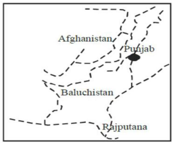
Consider the map given below: The dotted (broken) line in the map is the
A
Durand line
B
MacMahon line
C
line of demarcation between India and Pakistan suggested by the Boundary Commission (1947)
D
route followed by the young husband Expedition
Correct Answer: Option A
Explanation
1. The map shows the northeastern region of India, bordering China.
2. The dotted line represents an international boundary in this region.
3. The Durand Line is the border between Afghanistan and Pakistan.
4. The MacMahon Line is the boundary established between British India and Tibet in 1914, running along the crest of the Himalayas, and forms the effective boundary between India and China in the Eastern sector (Arunachal Pradesh region), though China disputes its legality.
5. The Radcliffe Line was the boundary demarcation between India and Pakistan in 1947.
6. The Younghusband Expedition (1904) was a British military expedition to Tibet, and the line does not represent its route.
7. Based on the geographical location depicted, the dotted line represents the MacMahon Line.
More Geography (World mapping) PYQs
- Consider the following countries : 1. United Kingdom 2. Denmark 3. New Zealand 4. Australia 5. Brazil How many of the above countries have more than four time zones?
- Consider the following pairs : 1. Country: Botswana, Resource-rich in: Diamond 2. Country: Chile, Resource-rich in: Lithium 3. Country: Indonesia, Resource-rich in: Nickel In how many of the above rows is the given information correctly matched?
- Consider the following pairs : 1. Region: Mallorca, Country: Italy 2. Region: Normandy, Country: Spain 3. Region: Sardinia, Country: France In how many of the above rows is the given information correctly matched?
- Consider the following countries : 1. Bolivia 2. Brazil 3. Colombia 4. Ecuador 5. Paraguay 6. Venezuela Andes mountains pass through how many of the above countries?
- Consider the following water bodies : 1. Lake Tanganyika 2. Lake Tonlé Sap 3. Patos Lagoon Through how many of them does the equator pass?
- Consider the following countries: 1. Finland 2. Germany 3. Norway 4. Russia How many of the above countries have a border with the North Sea?
Master UPSC Revision
Get 10,000+ topic-wise MCQs, spaced repetition, daily CSAT challenges, and detailed performance analytics.
Coming Soon to Play Store