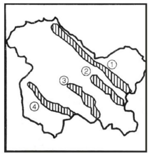
Examine the map of Jammu and Kashmir given below: The mountain ranges marked 1, 2, 3 and 4 are respectively
A
Ladakh, Zanskar, Karakoram and Pir Panjal
B
Karakoram, Ladakh, Zanskar and Pir Panjal
C
Karakoram, Zanskar, Pir Panjal and Ladakh
D
Ladakh, Pir Panjal, Karakoram and Zanskar
Correct Answer: Option B
Explanation
1. The question requires identifying the mountain ranges marked on the map of Jammu and Kashmir.
2. The major ranges in this region, generally arranged from North to South, are the Karakoram Range, Ladakh Range, Zanskar Range, and the Pir Panjal Range (part of the Lesser Himalayas).
3. Matching this sequence to the likely positions on a standard map representation where 1 is northernmost and 4 is southernmost among the main ranges shown:
- 1 likely represents the Karakoram Range.
- 2 likely represents the Ladakh Range.
- 3 likely represents the Zanskar Range.
- 4 likely represents the Pir Panjal Range.
4. This sequence corresponds to option B.
More Geography (Indian physical environment) PYQs
- With reference to the Himalayan rivers joining the Ganga downstream of Prayagraj from West to East, which one of the following sequences is correct?
- Consider the following information: | | Waterfall | Region | River | 1. Dhuandhar | Malwa | Narmada | 2. Hundru | Chota Nagpur | Subarnarekha | 3. Gersoppa | Western Ghats| Netravati | In how many of the above rows is the given information correctly matched?
- Consider the following statements : 1. Jhelum River passes through Wular Lake. 2. Krishna River directly feeds Kolleru Lake. 3. Meandering of Gandak River formed Kanwar Lake. How many of the statements given above are correct?
- Consider the following statements : 1. Amarkantak Hills are at the confluence of Vindhya and Sahyadri Ranges. 2. Biligirirangan Hills constitute the easternmost part of Satpura Range. 3. Seshachalam Hills constitute the southernmost part of Western Ghats. How many of the statements given above are correct?
- Consider the following trees : 1. Jackfruit (Artocarpus heterophyllus) 2. Mahua (Madhuca indica) 3. Teak (Tectona grandis) How many of the above are deciduous trees?
- Gandikota canyon of South India was created by which one of the following rivers ?
Master UPSC Revision
Get 10,000+ topic-wise MCQs, spaced repetition, daily CSAT challenges, and detailed performance analytics.
Coming Soon to Play Store