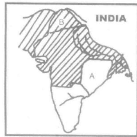
In the given map, the shaded part represents Akbar's empire at a certain juncture: 'A' stands for an independent country and 'B' marks the site of a city. Which one of the following alternatives gives all correct information?
A
Akbar in 1557: (A) Golkunda (B) Lahore
B
Akbar in 1557: (A) Khandesh (B) Multan
C
Akbar in 1605: (A) Gondwana (B) Multan
D
Akbar in 1605: (A) Gondwana (B) Lahore
Correct Answer: Option D
Explanation
1. The question asks to interpret a map showing Akbar's empire at a certain point, identifying an independent country ('A') and a city ('B').
2. Option (D) places the time as 1605, near the end of Akbar's reign. At this time, Akbar's empire was vast.
3. 'A' is identified as Gondwana. While parts of Gondwana were subjugated earlier, large tracts remained autonomous or independent feudatories outside direct Mughal administration.
4. 'B' is identified as Lahore. Lahore was a major provincial capital and strategically important city within Akbar's empire, located in the northwest, consistent with typical map representations.
5. Other options are less likely: 1557 was too early for the depicted extent. Golkunda was further south and remained independent until later. Khandesh was annexed earlier. Multan is another plausible city, but the combination Gondwana/Lahore for 1605 fits the historical context well.
More History (Medieval India) PYQs
- Who among the following led a successful military campaign against the kingdom of Srivijaya, the powerful maritime State, which ruled the Malay Peninsula, Sumatra, Java and the neighbouring islands?
- Who of the following rulers of medieval India gave permission to the Portuguese to build a fort at Bhatkal ?
- Who among the following rulers of Vijayanagara Empire constructed a large dam across Tungabhadra River and a canal-cum-aqueduct several kilometres long from the river to the capital city?
- Consider the following dynasties : 1. Hoysala 2. Gahadavala 3. Kakatiya 4. Yadava How many of the above dynasties established their kingdoms in early eighth century AD?
- Who among the following rulers of medieval Gujarat surrendered Diu to Portuguese?
- "Yogavāsistha" was translated into Persian by Nizamuddin Panipati during the reign of:
Master UPSC Revision
Get 10,000+ topic-wise MCQs, spaced repetition, daily CSAT challenges, and detailed performance analytics.
Coming Soon to Play Store