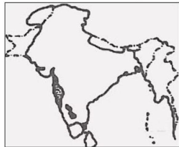
The given map refers to the kingdom of
A
Akbar at the time of capture of Khandesh in 1601
B
Akbar at the time of his death in 1605
C
Aurangzeb at the time of capture of Hyderabad
D
Aurangzeb at the time of his death in 1707
Correct Answer: Option B
Explanation
1. This question involves interpreting a historical map (not provided) to identify the extent of a kingdom at a specific time.
2. Option (A) and (B) depict Akbar's Mughal Empire around 1601-1605, which covered North India and extended into the Deccan up to Khandesh.
3. Option (C) relates to Aurangzeb's empire after the conquest of Hyderabad (Golconda) in 1687, reflecting a larger territory than Akbar's.
4. Option (D) represents the Mughal Empire under Aurangzeb at its maximum territorial extent at the time of his death in 1707, encompassing nearly the entire subcontinent.
5. If the map shows this maximum extent, including North India and most of the Deccan (Bijapur, Golconda etc.), it refers to the kingdom of Aurangzeb at the time of his death in 1707. (Analysis assumes the map depicts the largest extent).
More History (Medieval India) PYQs
- Who among the following led a successful military campaign against the kingdom of Srivijaya, the powerful maritime State, which ruled the Malay Peninsula, Sumatra, Java and the neighbouring islands?
- Who of the following rulers of medieval India gave permission to the Portuguese to build a fort at Bhatkal ?
- Who among the following rulers of Vijayanagara Empire constructed a large dam across Tungabhadra River and a canal-cum-aqueduct several kilometres long from the river to the capital city?
- Consider the following dynasties : 1. Hoysala 2. Gahadavala 3. Kakatiya 4. Yadava How many of the above dynasties established their kingdoms in early eighth century AD?
- Who among the following rulers of medieval Gujarat surrendered Diu to Portuguese?
- "Yogavāsistha" was translated into Persian by Nizamuddin Panipati during the reign of:
Master UPSC Revision
Get 10,000+ topic-wise MCQs, spaced repetition, daily CSAT challenges, and detailed performance analytics.
Coming Soon to Play Store