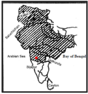
The shaded area in the above map shows the empire of
A
Ala-ud-din Khilji
B
Mohammad Tughlaq
C
Shah Jahan
D
Aurangzeb
Correct Answer: Option C
Explanation
1. The question asks to identify the ruler whose empire is represented by the shaded area on the given map.
2. (Assuming the map shows the maximum extent of the Delhi Sultanate, covering almost the entire subcontinent including the deep south). The Tughlaq dynasty, particularly under Mohammad bin Tughlaq, saw the Delhi Sultanate reach its largest territorial extent.
3. While Ala-ud-din Khilji's armies campaigned extensively in the South, the area under direct administration arguably peaked under Mohammad bin Tughlaq before subsequent fragmentation.
4. The Mughal empires under Shah Jahan and Aurangzeb were vast but had different boundaries, particularly in the northwest and the southern tip, compared to the peak Tughlaq extent.
5. Therefore, if the map shows the near-total extent including the far south, it likely represents the empire of Mohammad Tughlaq.
More History (Medieval India) PYQs
- Who among the following led a successful military campaign against the kingdom of Srivijaya, the powerful maritime State, which ruled the Malay Peninsula, Sumatra, Java and the neighbouring islands?
- Who of the following rulers of medieval India gave permission to the Portuguese to build a fort at Bhatkal ?
- Who among the following rulers of Vijayanagara Empire constructed a large dam across Tungabhadra River and a canal-cum-aqueduct several kilometres long from the river to the capital city?
- Consider the following dynasties : 1. Hoysala 2. Gahadavala 3. Kakatiya 4. Yadava How many of the above dynasties established their kingdoms in early eighth century AD?
- Who among the following rulers of medieval Gujarat surrendered Diu to Portuguese?
- "Yogavāsistha" was translated into Persian by Nizamuddin Panipati during the reign of:
Master UPSC Revision
Get 10,000+ topic-wise MCQs, spaced repetition, daily CSAT challenges, and detailed performance analytics.
Coming Soon to Play Store