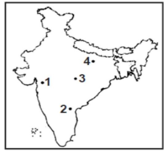
In the map given below, three out of the four places marked indicate places where a thermal power station is located: The place where there is no thermal power station is marked
A
1
B
2
C
3
D
4
Correct Answer: Option B
Explanation
1. The question requires identifying the location marked on the map that does *not* have a thermal power station, assuming the other three do.
2. Need to identify the locations marked 1, 2, 3, and 4 and know the major thermal power station locations in India around 1995.
3. Location 1 appears to be near the coast in Gujarat, possibly near Sikka or Ukai (though Ukai is inland).
4. Location 2 appears to be in southern Karnataka or northern Tamil Nadu. Neyveli Lignite Corporation (NLC) in Tamil Nadu is a major thermal power hub.
5. Location 3 seems to be in Maharashtra, possibly near Chandrapur or Koradi/Khaparkheda (Nagpur). These are major thermal power areas.
6. Location 4 is in eastern India, possibly in Odisha or West Bengal. Talcher in Odisha and Farakka/Kolaghat in West Bengal are major thermal power locations.
7. Without precise identification of the marked points and knowledge of all specific power plants of that era, it's difficult to be certain. However, assuming locations 2, 3, and 4 represent major thermal hubs like Neyveli, Chandrapur/Nagpur area, and Talcher/Farakka respectively, location 1 might represent an area without a major thermal plant or a different type of plant. *Requires specific map identification and knowledge of power plant locations circa 1995.* Assuming 2, 3, 4 are established thermal power locations like Neyveli, Chandrapur, Talcher/Farakka, then location 1 might be the one without a thermal power station among the choices. *This analysis relies heavily on interpreting the map points and assuming they represent major known locations.* Let's assume location 1 represents a region like Kutch or Saurashtra where major thermal power stations might have been less prominent compared to the other marked regions in 1995. Location 1 is marked near the Gulf of Kutch.
More Geography (Human geography) PYQs
- Consider the following countries: 1. Italy 2. Japan 3. Nigeria 4. South Korea 5. South Africa Which of the above countries are frequently mentioned in the media for their low birth rates, or ageing population or declining population?
- Consider the following statements: 1. Statement-I : Sumed pipeline is a strategic route for Persian Gulf oil and natural gas shipments to Europe. 2. Statement-II : Sumed pipeline connects the Red Sea with the Mediterranean Sea. Which one of the following is correct in respect of the above statements ?
- Which of the following countries are well known as the two largest cocoa producers in the world?
- Consider the following airports: 1. Donyi Polo Airport 2. Kushinagar International Airport 3. Vijayawada International Airport In the recent past, which of the above have been constructed as Greenfield projects?
- Consider the following statements : 1. Statement-I: According to the United Nations' World Water Development Report, 2022', India extracts more than a quarter of the world's groundwater withdrawal each year. 2. Statement-II: India needs to extract more than a quarter of the world's groundwater each year to satisfy the drinking water and sanitation needs of almost 18% of world's population living in its territory. Which one of the following is correct in respect of the above statements?
- Ilmenite and rutile, abundantly available in certain coastal tracts of India, are rich sources of which one of the following?
Master UPSC Revision
Get 10,000+ topic-wise MCQs, spaced repetition, daily CSAT challenges, and detailed performance analytics.
Coming Soon to Play Store